Despite the fact that Bingham Canyon contains one of the largest ore deposits in the world, it was decades before it received any serious attention from the mining industry. Here is an article that describes the mining districts of the Oquirrh Mountains. It was written by B.A.M. Froiseth, Utah's first cartographer. Discussion of Bingham Canyon here is limited to just a few sentences, but prior to this, Utah's first mining district was virtually ignored by the press.
Elsewhere on this site it is demonstrated that various members of the Hickman family were involved in the discovery and organizing of nearly every district in the Oquirrhs. This article was published the very same month that the attention of the world would turn to Bingham following the gunfight between Gabriel Cotton and two of his sons with Bill Hickman's son-in-law Samuel Monroe Butcher. Gunfights were common in those days, especially at Bingham Canyon--but what made this one special was the number of victims, which set something of a record.
For Crofutt's Western World.
MINING IN UTAH.
The Districts of the Oquirrh Mountains.
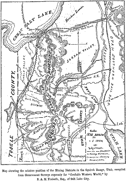
The Oquirrh range is a chain of mountains in Utah Territory, commencing at a point on the Great Salt Lake, running north and south in an almost perpendicular line for nearly 35 miles, and forming the divide between Salt Lake and Tooele Counties. There are 5 organized Mining Districts in this range, the relative positions of which may be seen by the Map on page eight, viz: Bingham Canon, Tooele, Rush Valley, Ophir and Camp Floyd, all situated in the same mineral belt, and similar to each other in formation, being principally granite and limestone. These districts, except Bingham Canon, are all in Tooele Co., in a south westerly direction from Salt Lake City, and are accessible from it at, present only by Wine's & Kimball's daily stage line, but before the close of this season, the Bingham Canon R. R., now under construction, and the Salt Lake Sevier Valley, and Pioche R. R., which is being rapidly pushed forward will be complete, which will bring these districts in direct rail communication with the city. These roads will certainly be the means of greatly enhancing the value of the mines in these localities, by rendering them of more easy access to the public, and also by giving shippers a better means of transporting their ores.
West Mountain or Bingham Canon Mining District is situated on the eastern slope of the mountains, 25 miles wide by 12 miles long and is composed of several canons and gulches, in each of which ore of a certain character predominates. The ores are very varied, embracing among others, grey carbonates of a high grade, sulphurets, bromides, oxides and large quantities of milling ores, and valuable placer claims have also been worked. The district was organized in 1863, and a good many locations made during the two following years, but it is within the last two years that the principal developments have been made. Bingham Canon contains a large number of very valuable mines, among which may be classed the following:--Winnamuck, Portland, Red Warrior, Last Chance, Dartmouth, Belshazzar, West Jordan, Grand Cross, Silver Shield, Live Pine, Telegraph, Vespasian, Osceola, Lucky Boy, Washington, Queen, Legal Tender, Merrimac, Orphan Boy, and many others which space forbids me to mention.
TOOELE MINING DISTRICT
is situated on the west slope of the Oquirrh range, 30 miles from Salt Lake City. It is about 8 miles long and three miles wide, but has not received the same attention as the other districts in the same vicinity. The ores are both milling and smelting, and when the district is more developed, it will probably be as valuable as the others, as it contains a number of very good prospects. The Clipper is the only developed mine, which shows good bodies of carbonates and argentiferous galena.
STOCKTON OR RUSH VALLEY MINING DISTRICT
is also on the west slope of the mountains, about 37 miles from Salt Lake City. It was organized in 1864, and is about 6 miles long by 5 miles wide. Stockton is destined to be one of the finest smelting districts in the Territory, as it possesses every facility for success in that branch of mining. It forms a natural smelting center for several reasons; its geographical location, the character of its ores, and its relative position to several other districts which produce various smelting ores in large quantities, and these advantages combined, cannot fail to render it very successful, especially when aided by the important auxiliaries of capital and enterprise.
There are two smelting works at Stockton, the Waterman and Jacobs & Co.'s works, both in constant and active operation. The following are among the principal mines in this district:-Silver King, Silver King No. 2, Quandary, Margaret, Muscatine, Metropolitan, Legal Tender, Our Fritz, Silver Queen, Tucson, Bolivia, Last Chance, Defiance, Vulcan, St. Patrick, Peabody, May Bell, Mineral Hill and Lady Douglas.
OPHIR MINING DISTRICT,
is on the west slope of the range, 45 miles from Salt Lake City. It is 6 miles long by 5 miles wide, and consists of East Canon, Lion Hill, Silverado Hill, Chloride Hill, and Dry Canon. It was organized as recently as 1870, and already contains a large number of well developed mines, besides two Stamp Mills, and three smelting works in East Canon, one of which the Pioneer Mill was the first erected in the Territory. The ores are generally high grade and are about equally divided, one half being milling and one half smelting ores.
The principal mines in Ophir are the Tiger group situated in East Canon, comprising the Tiger, Silver Chief, Zella, Rockwell, Mountain Lion, Home Stake, Defiance, Sunny Side, Silver Exchange, Miners' Delight, or Blue Monster Consolidation, Hidden Treasure, Poor Mans' Friend, Antelope and Silver Tail, also in East Canon; in Dry Canon, the Mono, Pocohontas, Chicago, Iris, Utah Queen, Hidden Treasure, Congress, Evening Star, Young America, Mountain Chief and Iron Duke on Chloride Hill, San Joaquin, and Chloride Jim.
CAMP FLOYD MINING DISTRICT,
is on the west slope of the mountains, about 60 miles from Salt Lake City. It was organized early in 1871, and is about 5 miles long by 6 miles wide, and contains nearly 300 locations, a large number of which are now well developed mines. This district is within 20 miles of railroad communication, connecting with the Utah Southern R. R. at Lehi, and a road is proposed to run from Lehi to Fairfield, where Baxter's custom mill is erected for the reduction of Camp Floyd ores. The Camp Floyd Silver Mining Co.'s Mill is situated at Lewiston, and was intended to work ores only from the Co.'s mines, but is now also doing custom work. Camp Floyd contains a large number of good mines among which may be mentioned the Sparrow Hawk, Last Chance, Marion, Mormon Chief and its extensions, the Grecian Bend and London, Camp Douglas consolidated, General Morrow, Silver Cloud, Star of the West, Stafford, Carrie, Steele, Antelope, Queen of the West, Elkhorn, Silver Circle, Wandering Boy, Legal Tender, Comstock, America, Lone Star, and Excelsior.
--Crofutt's Western World, July 1873 p.9
To learn more about the Butcher-Cotton gunfight, click here.
To return to the Hickman Family index page, click here.